SUGARLOAF CRESCENT
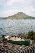 Pictured at top left is Sugar Loaf Mountain in Greers Ferry Lake. There's a well-maintained hiking trail to the summit. The trail is accessible only by water, which is why you see my canoe in the foreground. To get to Sugar Loaf, take hwy 16 south from the town of Greers Ferry, turn right on hwy 92 and turn off when you get to hwy 337. When you get to the end of hwy 337, get in your canoe and paddle out to the island.
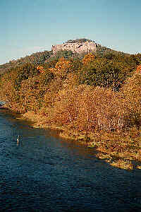 This is also Sugar Loaf Mountain on the right. It's only about fifteen miles from the Sugar Loaf Mountain in the picture on the left. To get here you take highway 110 east from Heber Springs. There's an easy trail up to those bluffs, but getting to the summit requires some determination and a little skill. Incidentally, that fisherman in the lower left corner is fishing in the Little Red River, the same waters that produced the current (as of this writing) world's record brown trout. The fish was caught in 1992 by a Heber Springs resident and weighed in at 40 pounds, 4 ounces.
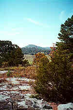 Head up the road (that's highway 5) about forty miles to Calico Rock. Drive to the base of the water tower, look to the south and you'll see this peak pictured on the left. No, it's not called Sugar Loaf. It's called Sugarloaf. One word--Sugarloaf, to distinguish it from the two-word Sugar Loaf Mountains described above. Sugarloaf south of Calico Rock has a lookout tower on the summit, but I don't know if the public is allowed in the tower.
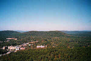 Here's another (one-word) Sugarloaf Mountain in the center of the photo on the right. To get this view go Hot Springs, drive up Hot Springs Mountain Road, pay your five bucks and take the elevator to the top of the observation tower. That cluster of buildings on the left in front of Sugarloaf is the Arkansas School of Mathematics and Science.
Had enough, soldier? Sir, no, sir! 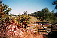 Drive twenty miles southwest of Sugarloaf Mountain (Hot Springs) on highway 70. Turn south on highway 182. Turn right on the first dirt road after you cross the Caddo River. Look to your right and see the view pictured here on the left. This is Sugarloaf Knob and it's on private property. To the left of that gate is a large red-on-white sign overgrown with honeysuckle that reads something to the effect "Restricted Area: Authorized Personnel Only."
Take highway 7 north from Harrison. 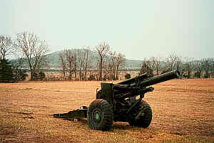 There is another Sugarloaf Knob up north right near the Missouri Border just about a mile northwest of the town of Lead Hill. That's Sugarloaf Knob on the horizon, guarded in this picture by a 155mm towed howitzer stationed in a pasture next to American Legion Post 304 (That's the Douglas MacArthur post to you, bub.) between Lead Hill and Diamond City.
After Lead Hill, backtrack to Harrison and take highway 62 west. After you pass Eureka Springs and cross the bridge across Table Rock Lake. 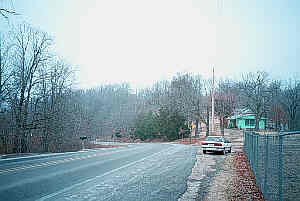 About four miles past the bridge, look to your right and find yet another Sugarloaf Mountain. Or you can drive to the Benton County line at the rock cutaway, turn around and drive east on 62 for 6/10ths of a mile and you'll be here. You don't really get a sense of a hill from this picture because the road skirts so close to the summit, but if you use your imagination a bit and you keep in mind that the road here curves to the left to go around the mountain, you can see the crest just above and to the left of the house. Honest to Pete, the summit is right in the center of the picture.
Well, that about does it for all the Sugarloaf Mountains and Sugar Loaf Mountains and Sugarloaf Knobs in Arkansas. 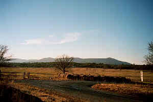 But wait! There is yet a Sugarloaf Range that straddles the Arkansas/Oklahoma border like a giant staple connecting the two states. (The combined states were at one time a single region set aside as Indian territory). Of that range, two peaks in Oklahoma and two are in Arkansas. Here's a photo taken from the south side of the range from highway 96 near the town of Hartford. There is also a Sugarloaf Lake on the north side of that range on the Arkansas side. The range is oriented southwest to northeast and stretches from Monroe, OK to Midland, AR.
Geographical Coordinates of Arkansas' SugarLoafs
- 35deg29min28secN,091deg59min08secW (Barnett Access)
- 35deg02min14secN,094deg26min32secW (Sugarloaf Range)
- 35deg33min40secN,092deg15min58secW (Greers Ferry)
- 36deg05min04secN,092deg09min48secW (Calico Rock)
- 34deg18min20secN,093deg26min03secW (Amity)
- 36deg25min54secN,092deg53min52secW (Lead Hill)
- 36deg28min58secN,093deg51min16secW (Beaver)
- 34deg31min13secN,093deg04min55secW (Hot Springs)
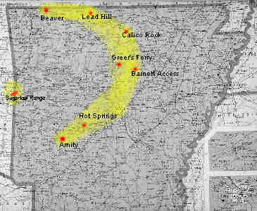 Now for the spooky part. Mark these eight points on a map and that map looks like this. I added the yellow parts to emphasize the crescent-and-star motif, although the addition of emphasis hardly seems necessary in this case.
I'm willing to entertain the possibility that this arrangement is accidental. After all, next to triangles, circles and crosses, the star and crescent is one of the easiest motifs for the eye to discern within random patterns.
I can also imagine that this arrangement occurred by deliberate design. The star and crescent is a common symbolic device in any number of secret fraternal orders, and some of those members might have thought it a clever, private geographical joke to make this gesture. In effect, this SugarLoaf Crescent and Star might be fraternal regalia writ large across the map of Arkansas. If that is the case, sadly we will probably never know. Them masons and mooses and elks and oddfellows and shriners is awful dang cagey about the stuff they'll admit to.
By the way, I also plotted the occurrences of Sugarloaf mountains, knobs and hills in Oklahoma. There are no summits named Sugar Loaf in any bordering state except Oklahoma. I decided not to include the Oklahoma data here; but comparing and combining the Oklahoma points with the Arkansas points could be illuminating, should anybody out there care to examine the sugarloaf (sucre l'oef) phenomenon further.
RTJ--11/3/98
RTJ--2/12/99
RTJ--2/1/2001
Arkansas Travelogue home page